Ancient Footpaths
Native American Indian Trails
|
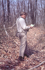
This Ancient Footpath, located on the "Great Indian Warpath" from SE Us to midwest via Scioto Salt Springs, is called Virgin Trail by The Olde Forester as it never became a road for European settlers. It is located in northwest Jackson County on Mead Corp property. The trail is believed to be an unimproved portion of the "Road from the Highbank Prairee" (Pickaway Plains, long an Indian village site south of Circleville, OH) to Salt Lick Town (now Jackson, OH). Photo by Emmett Conway about 1978 when first exploring ancient trails. |
By Emmett A. Conway, Sr., The Olde Forester
Only the streets remember. This was the laconic
reply of the German farmer in Waldkirk, Black Forest, Germany, when I asked
him if there had ever been charcoal iron blast furnaces in the village.
His remark reminds us of how soon we forget. The good part is that it reminds
us that the names of roads are often a clue to historical sites.
When our species of bipeds appeared on earth in
that dim and unknown past, they used their feet to find places to supply
their needs. Supplying the primary wants of food and shelter required moving
around the territory in which one found oneself. Hunters and gatherers
would travel from places of nightly repose to seek a food supply of berries,
roots, nuts, fish, insects or animals. In doing so they packed the earth
proportionally to the continuity of use and condition of the terrain. Thus
ANCIENT FOOTPATHS were established wherever people lived. Footpaths etched
the habits of the ancient people on the earth.
Animals, particularly grazing animals, created
traces for similar reasons. Mammoths, mastodons, extinct bison, deer, elk
and other migratory animals probably were the originators of the main trails
followed by early Indians in North America. They found the fordings of
the streams and rivers, the low gaps in a hill or mountain range and the
unerring direction to places of importance to them. Points of intense concentration,
like the prime salt
springs where Jackson,
Ohio, is now located, were approached from all important directions.
The modern road map shows this site to be a veritable hub of roads--many
on the same locations as the ANCIENT AND GAME PATHS recorded before settlement
in 1796. Portions of these "Buffalo Traces" can still be found cut to the
depth of eight feet below the surrounding terrain. One thrills to the thought
that mammoths and other Pleistocene vertebrates helped cut them on their
way to the licks and that Paleo Indians followed them there.
Some frontiersman said, "The Indian Trails were
laid out by the Buffaler, the Injin and the Injineer."
Geography and common observation teaches us that
the environment is a varied and changing habitat for mankind. We have oceans,
rivers, lakes, swamps, deserts and wetlands, and various elevations above
sea level. Different weather conditions are brought about by latitude,
longitude and elevation. There are natural resources which the people found
useful such as salt, flint, various kinds of rocks (for hammerstones, etc.),
and metals (copper, silver, lead, etc.) which they learned to make into
tools and ornaments. People have adapted to these natural conditions and
resources in a myriad of ways. Topography and the natural resources had
a great influence on the locations of the many primary ANCIENT FOOTPATHS.
The late Dr. Paul A. W. Wallace made a lifetime
study of Pennsylvania Indian paths which was published in 1965 by The Pennsylvania
Historical and Museum Commission entitled, Indian Paths of Pennsylvania.
He characterizes Indian paths as being DRY, LEVEL AND DIRECT. A locational
engineer would be proud of the placements and alignment.
THE ANCIENT FOOTPATHS
OF ATHENS COUNTY have been located with little doubt because of documentation
by The Ohio Company pioneers. Federal law dictated that the specifications
of THE RECTANGULAR SYSTEM OF LAND MEASUREMENT be adhered to by The Ohio
Company of Associates. In surveying the lines of the six mile square townships
and the mile square sections and subdivisions, the surveyors were required
to record geographic conditions along the lines including roads and streams.
The original survey notes and plats are located in the archives of the
Marietta College Library and were not in the custody of the State Auditor
of Ohio as are all other original surveys.
The surveyors were the elite scientists of the
pioneer days, and generally the leaders, for example, Rufus Putnam. Their
notes and plat maps are in the archives of the Marietta College Library,
Marietta, Ohio. Their specific notes on the locations of existing traces
and roads before or just after the time of settlement are vital to relocating
the Indian Paths.
Indian Paths and Ancient Footpaths around the
world have proven to be the easiest routes to walk from place to place
for very long distances--hundreds and thousands of miles. The portions
crossing the present Athens County are part of the continental system and
similar to ANCIENT FOOTPATHS the world around. The characteristics mentioned
by Paul A. W. Wallace of DRY, LEVEL AND DIRECT fits the portions of the
trails in Athens County. He also states, "These Indian Paths of Pennsylvania
continue to be important Indian sites in Ohio and elsewhere."
The odd curve in the river which the Indians had
named "HOCKHOCKING"
and which was chosen as a seat of higher learning, had long been popular
with the Indians. See James L. Murphy's book entitled, An Archeological
History of the Hocking Valley, Ohio University Press, Athens, Ohio,
1975. Two prominent Indian village sites are mentioned along with many
mounds and the spectacular Wolf Plains Complex of earthen circles and many
mounds. It is not surprising that the first state-wide map of the original
survey, THE HOUGH MAP OF 1815, (a copy of a portion of it was given to
the Special Collections Division of the Alden Library) clearly shows five
long distance roads coming together at the City of Athens. The Hough Map
shows each square survey township and its subdivisions into thirty-six
sections, or in the Ohio Company Tract, sections and fractional sections.
The belief of the author is that the politicians had not yet had time to
modify the Indian Paths to the settlers' demands; and therefore, indicate
the typical Ancient Footpath characteristics.
Another map which shows the principle roads, presumed
to be ancient footpaths, is THE
MAP OF THE STATE OF OHIO drawn by A. BOURNE, and dated 1820. The title
states, "INCLUDING THE INDIAN RESERVATIONS."
The Olde Forester hopes to document all he knows
about the ancient footpaths. To date I have the following entries:
Return
to Native American Indians

Return
to The Olde Forester
Webmaster: Daughter Sandra
Conway Morrissey