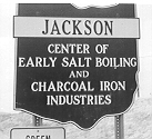
 The City of
Jackson was "The Center of Early Salt Boiling" -- as this historic marker
on the city limits once declared. There is considerable historical
importance attached to the making of salt, and one would wonder where and
how this took place.
The City of
Jackson was "The Center of Early Salt Boiling" -- as this historic marker
on the city limits once declared. There is considerable historical
importance attached to the making of salt, and one would wonder where and
how this took place.
|
Killed at ye Salt Licks on Siota
|
|
From Col. Bouquet's Reports in British Museum (1763-1764) |
The City of
Jackson was "The Center of Early Salt Boiling" -- as this historic marker
on the city limits once declared. There is considerable historical
importance attached to the making of salt, and one would wonder where and
how this took place.
While white salt boilers found that they could obtain
salt water by digging wells in the alluvium along Salt Lick Creek for a
distance of four miles above and below Jackson, there were but two principal
locations thought worth recording by the federal land surveyors in 1798.
A plat map found at the Jackson County Engineer's Office and, also, at
the Auditor's Office of the State of Ohio shows two easily-located sites
called, "Salt Springs." (Ref.
1)
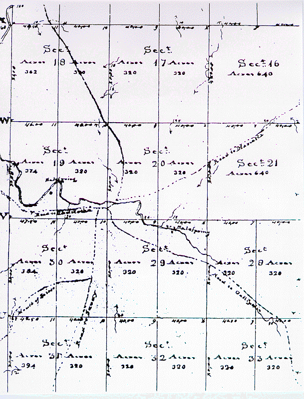 |
| Original map of the center of the Scioto Salt Reserve as mapped by Eli Langham, 1798, by order of congress, 1796. |
The other "Salt Springs" shown on the 1798 plat map made by Elias Langham was in the north end of the east half of Section 29 and specifically spotted along the north bank of Salt Lick Creek and east of the mouth of Sugar run. These springs would have been "At the foot of Broadway" as described by early historians and on the site now occupied by the city light plant, equipment parking lot and an active city dump.
There are a surprising number of references to the "Scioto Salt Springs" and "Scioto Salt Works" as they were known to the Native Americans, traders, and settlers until their decline about 1816. At that time SALT LICK TOWN became Jackson, Ohio. It is the purpose of the writer to present a wide variety of authentic observations and data on the way the salt springs at Jackson filled the need for salt--the most needed and most scarce commodity on the frontier.
Salt springs were a natural gathering place for grazing animals. These attracted the carnivores. Both attracted the Native Americans for meat as well as salt. The Scioto Licks at Jackson exhibited all the characteristics of this activity, having been available for countless centuries--even preceding the Glacial Period when extinct animals inhabited the region. The impact of European colonization led to its demise. Now increasing urbanization is threatening the final destruction of what remains of the Scioto Licks.
To appreciate the importance and significance of the Scioto Salt Springs, one has to think back beyond 160 years before salt became a common item. Back to the time when people had to rely on natural flowing salt springs at inland locations or transport salt from seaside or saline lakes. Successful drilling for richer brines about 1810 marked an end to the boiling of weak surface salt springs.
The Scioto Salt Springs are but thirty miles from
the glacial front and behind a range of hills which would have provided
somewhat of a barrier to the chilling ice. This fact plus the availability
of low arctic vegetation and the salt springs made conditions favorable
for the survival of prehistoric mammals.
Extensive research in Kentucky at Big
Bone Licks has related the above condition to the common occurrence
of these extinct creatures who left their bones engulfed in the mud, clay,
and gravel at their common meeting grounds--the salt licks. Among the animals
listed are: mammoths, mastodons, peccaries, tapirs, Arctic bear,
elk, and the phylum of major and minor fauna.
Over the hundreds of thousands of years of the existence
of these prehistoric animals, the Scioto Salt Springs was an attraction
to them, because there are ample records of their bones being commonly
found in digging salt wells in the alluvium.
The Ohio Geological Report of 1838 contains,
probably, the most complete and authentic description of prehistoric animals
in relation to the Scioto Salt Springs. The geologist, C. Briggs,
Hildreth, and others obtained detailed information directly from their
learned friend, George L. Crookham. Crookham, a naturalist, teacher
and scholar had had the opportunity of examining the many fossil bones
and whatever other curiosities the early salt boilers found in the Salt
Spring neighborhood. The geological corp in 1837-38, no doubt, quizzed
him avidly and felt assured of his accurate observations.
Briggs and the other geologists had the thrill,
themselves to unearth the remains of a mammoth skeleton which had been
on the way or leaving the Scioto Salt Springs. They learned of the
finding of some bones on a branch of Salt Creek in the northwest part of
Jackson County about two years previously to the time of their survey (circa
1836). Their subsequent research on the site and recorded observations
will be most useful in analyzing the potential for finding similar fossil
bones today.
Geologists are stratification experts and, in this
case, may have provided the clue to findings in the valley at Jackson.
It will be observed in the quotation below from Briggs' report, and his
description later in this report that it was found that the Sharon conglomerate
rock which is in the bed of the stream at Boone Rocks dips rapidly to the
eastward. They discovered this in digging wells to procure a more
plentiful quantity of salt water. Briggs explains that the "mud wells"
were in stratified layers of clay, sand, and gravel, to a depth of 30 feet.
He says that these occupy a basin-shaped cavity in the conglomerate which
they identified as the "salt rock." "The brine," he states, "without
a doubt, was produced by the percolation of water through the rock into
this reservoir."
The stratification record which I wish to call attention
to is that record in a plate in the 1838 Geological Report which
shows mammoth bones under a stratified layer of clays of various characteristics.
These gentlemen successfully dug and recorded their findings at the site
of the mammoth find in the north-west part of the county.
Fossil Bones.
As before observed, some of the salt wells in Jackson
county were dug in a deposit of clay, sand, and gravel, occupying a basin-shaped
cavity in the superior part of the conglomerate. In nearly all these
wells were found fossil bones, consisting of jaws, teeth, tusks, vertebrae,
and ribs, which, from the descriptions given
by Mr. Crookham, belong to extinct species of animals. From his descriptions,
remains of the megatherium, and of the fossil elephant, were among the
number.
Mammoth, or Fossil Elephant.
In the early 1970s, some bones, so large as to attract
the attention of the inhabitants, became exposed in the bank of one of
the branches of Salt creek, in the northwest part of Jackson county.
They were dug out by individuals in the vicinity, from whom we obtained
a tooth, a part of the lower jaw, and some ribs.
In the examinations at this place, during the past
season, it was concluded to make further explorations, not only with the
hope of finding other bones, but with a view of ascertaining the situation,
and the nature of the materials, in which they were found. The mutilated
and decayed fragments of the skull, two grinders, two patellae, seven or
eight ribs, as many vertebrae, and a tusk. Most of these are nearly
perfect, except the bones of the head. The tusk, though it being
very frail, it was necessary to saw it into four pieces, in order to remove
it.
The following are the dimensions of the tusk, taken before it
was removed from the place in which it was found:
Length on the outer curve........10 feet 9 inches.
" "
inner curve........ 8 " 9 "
Circumference at base............ 1 " 9
"
"
2 feet from base... 1 " 10 "
"
4 " " ... 1
" 11 "
"
7.5 " " ... 1
" 7.5 "
This tusk weighed, when taken from the earth, 180
lbs. The weight of the largest tooth is 8-1/4 lbs.
These bones were dug from the bank of a creek, near
the water, where they were found under a superincumbent mass of stratified
materials 15 to 18 feet in thickness. The arrangement of these
materials, and the relative position in which these interesting fossils
were found in the following layers:
No. 1 is a yellowish clay, or loan, which now forms the surface
of swamp about one mile in length, and one-fourth to half a mile in breadth.
It is covered with large forest trees, many of which from their size, must
have been growing some centuries-- 5-1/2 feet.
No. 2. This layer is a yellowish sandy clay--7- 1/2 feet.
No. 3 is an irregular layer of ferruginous sand, tinged with
shades of red and yellow, and partially cemented with iron--4 to 8 inches.
No. 4 is a chocolate colored clay of mud, the inferior part of
which contains the remains of a few gramineous plants, very much decayed--2
feet.
No. 5. Sandy clay, colored, like No. 4, but a little lighter--1-1/2
foot.
No. 6 is the stratum containing the bones. It consists,
judging from external characters, of sand and clay, containing a large
proportion of animal and vegetable matter--1 to 1-1/2 foot.
These bones, from their position, had evidently
been subjected to some violence before they were covered with the stratified
deposits which have been described.
The jaw and grinders, with the other bones
which we have thus slightly noticed, evidently belong to an extinct species
of the elephant, now found in a fossil state. As the teeth differ
from any which are figured and described in the books to which I have access
at the present time, it is possible they may belong to an undescribed species.
The full effects of the glacial period was quite
unknown to the primary geologists of Ohio. They surmised that drainage
patterns had been altered and subsequent depositions partially filled older
valleys. They did not realize the extent of interglacial flooding
which filled pre-glacial valleys, including that of Salt Lick Creek.
As at Big Bone Lick, there would have been a backwater into the tributaries
of the Scioto or earlier Teays River. These periods of deposition
left identifiable stratifications--many with remains of trees, and other
vegetation and animal entrapments.
Briggs' detailed description of these 15 to 18 feet
of stratification materials under which the mammoth skeleton was unearthed
is a perfect clue to matching strata which might be found in the immediate
vicinity of the salt springs at Jackson. Bones and tree parts have
been found in deep-buried clay strata in the Hocking and Scioto Valleys
which drained from glacial front.
There should be a relationship between the post-glacial
deposits at the mammoth site and the salt springs with relation to the
possibility of finding other buried fauna.
Salt in Ancient Times
Sodium and chlorine, the two elements which combine
to produce a substance called sodium chloride or common salt, are two of
the ten major elements necessary for plant and animal life. Animals
ingest it as part of the food they eat or they eat it directly to satisfy
an inborn desire. A certain level must be maintained in the body
for good vigor and growth. Excessive losses must be replaced as from
perspiration. The need for salt has caused it to be an important
item of trade and political weapon.
The National Geographic of August, 1975,
has an article by Georg Gerster picturing salt cakes of ancient style in
modern Africa being sold in a market place. He states:
Once, salt was a cargo so precious that 12th century traders reportedly
exchanged it for twice its weight in gold. Camel caravans still carry
slabs from the Sahara to the Niger, where they are transported upriver
to the market at Mopti, Mali. (Ref.
2)
Salt has left its name on the geography of the earth
and in the language. In Italy, one of the oldest roads was called
the Via Salaria (salt road). The roads leading to Jackson, Ohio,
were once called "Salt Roads." the caravan trade of the Sahara Desert
is said to have been a trade in salt. The most prominent salt
springs seasonally attracted herds of buffalo, elk, deer, and smaller game
which through years of repetitious movement carved an extensive system
of traces. Prehistoric and extinct mammals; such as the mastodon,
mammoth, giant sloth and bison, no doubt initiated these ancient paths
in the Ohio Valley, including those in Jackson County.
Salt Springs and the Native
Americans
An official state dig was made at Boone Rocks and
several rock shelters in the summer of 1905 under the direction of William
C. Mills of the Ohio Archaeological and Historical Society (ref.
4). His stated objective was "to determine, if possible,
whether the rock shelters and other places of abode were occupied for any
great length of time as a domicile by prehistoric man or were used as temporary
and convenient stopping places for roving banks in search of food."
The report by Prof. Mills is to be found in the annual reports of the society
in Volume 2, Part 2, 1912. It is entitled, "Certain Mounds and Village
Sites in Ohio--Archaeological Remains of Jackson County." This was
a separate printing available at the Ohio
Historical Society.
Professor Mills' report lauds the richness of the
Boone Rocks Site. It was the best and most favorably known because
of the great number of Indian artifacts found in the shelter and in the
ground adjacent. Mills' report indicates that he reviewed the results
of private digs in the Boone Rocks site, some of these men having invited
the state to include it in their research. A contributor of note
was Mr. F. E. Bingman who studied and wrote "Archaeology of Jackson County,"
published in one of the local papers, beginning of January 9, 1897.
Two collectors, Judge H. C. Miller and W. A. Steele presented the major
parts of their finds in Boone Rock Shelter Site to the Ohio State Historical
Society.
Sad to say, many of the finds by local pot-hunters
in this prolific reservoir of Indian artifacts called locally, "The Bone
Yard," were carted away and lost. Pictures of Mills' dig show crude
methods, common to the time and, undoubtedly, would have missed smaller
artifacts which could have been found by screening.
Christopher Gist, a professional surveyor and explorer
for The Ohio Company of Virginia (not the later Ohio Company from New England
who settled Marietta) was sent on an exploratory trip into the Ohio Country
in the winter of 1750-51. His journal (Ref.
5) records his interest in salt springs and describes their
characteristics as they appeared in Native American Indian times.
Speaking of the Licking River west of modern Zanesville, Ohio, we quote,
"Set out SW 25M, to Licking Creek--The Land from Muskingum to this Place
rich but broken--Upon the N Side of Licking Creek about 6M from the Mouth,
are several Salt Licks, or Ponds, formed by a little Streams of Dreins
of Water, clear but of a blueish Colour, & salt Taste the Traders and
Indians boil their Meat in this Water, which (if proper Care be not taken)
will sometimes make it too salty to eat."
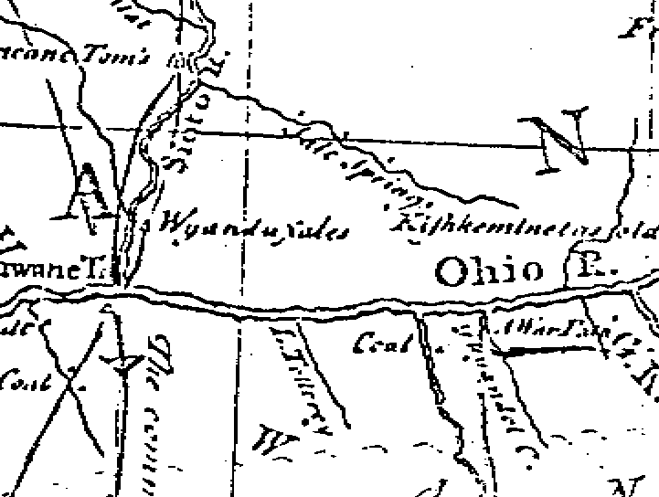
Gist provides the first English description of the
Scioto Salt Springs at Jackson when nine days later he had left the Pickaway
Plains Indian town of Maguck for Lower Shawnee Town at the mouth of the
Scioto River. His party of traders and Indian guides arrived at the
Scioto opposite Higby after passing through "fine level Land to a small
Town called Harrickintoms" (shown on the 1755 Louis Evans Map). "Friday
25.--The Creek being very high and full of Ice, We coud not ford it, and
were obliged to go down it on the SE side SE 4M to the Salt Lick Creek--about
1M up this Creek on the S Side is a very large Salt Lick, the Streams which
run into this Lick are very salt, & tho clear leave a blueish Sediment:
The Indians and Traders make salt for their Horses of this Water, by boiling
it; it has at first a blueish Colour, and somewhat bitter Taste, but upon
being dissolved in fair Water and boiled a second Time, it becomes tolerable
pure Salt." Later in his journey, Gist was to take note of salt licks
in Kentucky and marvel at the huge bones of a large beast found at a "salt
Lick of Spring upon a small Creek which runs into the S Side of the Ohio,
about 15 M, below the Mouth of the great Miamiee River, and 20 above the
Fall of Ohio"--Big Bone Lick.
The Moravian hero-missionary, the Reverend David
Zeisberger, labored for fifty active years among the Delaware Indians.
Among his many literary accomplishments, being a dedicated diarist and
report-conscious churchman, is his, "History of the Northern American Indians,"
published in the 1910 Ohio Archaeological and Historical Publications,
Vol. XIX, pages 1-189. Written at his mission home near New Philadelphia,
Ohio, in 1779 and 1780 for his superior of the United Brethren Church,
he describes the characteristics and habits of the Native Americans during
the Indian-White Contact Period in Ohio and the physical characteristics
of Ohio geography. In this treasure-trove is his description of salt
springs and the use made of them by Native Americans.
Salt Availability
and Ohio History
The history of Ohio is one of rapid technical development.
Persons of ingenuity were attracted to the Ohio Country from the earliest
times of exploration, settlement, and post-frontier days. They applied
themselves to the production of salt.
The first production was for personal use and the
live stock industry. When supplies became more available, salt was
used for preserving and curing meats and other food stuffs. After
human needs were met, salt was used for glazing ceramics and, later, has
become the basic ingredient of giant chemical industries.
Production methods progressively improved and richer
sources of the mineral were found. The Scioto Salt Springs were the
most important source of salt in Ohio until approximately 1816 when it
was found that you could drill a hundred feet or more and find richer brines
than those which exuded from the surface of the earth. The race from
then on is amply documented in the reports of the Ohio Geological Survey.
The first salt well west of the eastern mountains
was on the Great Kanawha, where in 1807, a brine was found which only required
200 gallons per bushel of 50 pounds of salt. The first well in Ohio
to be successfully drilled was at Gallipolis in 1809 where at 100 feet,
they reached water of 400 gallons per bushel. Drilled wells at Jackson
did not prove successful which led to the rapid decline of that source,
as greatly increased demands for salt had to be met elsewhere (Ref.
3).
 |
Objectives of Congress
The Northwest Territory embraced states which are
far beyond the present bounds of Ohio; therefore, the historian will find
references to early Ohio in historical accounts of Indians, Illinois, Michigan,
and Wisconsin. Sometimes, those states have more important articles
on early Ohio history than we do here, because of such eminent historians
as Rueben Thwaites and Frederick Jackson Turner.
Congress determined to have an orderly and, hopefully,
profitable disposition of the lands in the Northwest Territory, in contrast
to the hetler-skelter, indiscriminate squatter-style of land settlement
which had taken place in the individual thirteen colonies and territories.
A committee was appointed which in May, 1774, reported, "An Ordinance for
Ascertaining the Mode of Locating and Disposing of Lands in the Western
Territory." Thomas Jefferson was chairman of that committee(ref.
12).
"The Northwest Land Ordinance" of 1787 was a companion
piece of legislation to provide for orderly governance and development
of the Northwest Territory. Individual rights were to be protected
and private exploitation of limited resources, such as known salt springs,
were to be controlled.
Importance
of the Original Land Surveys
Jefferson's Land Ordinance Committee established
a rectangular system of land subdivision before settlement, rather than
to follow the older pattern of indiscriminate land claims. Land grants
had to be a subordinate, referenced portion of townships six-mile square.
Townships wee subdivided into thirty- six sections of one-mile square.
All of this was to be done before claims could be granted.
Nor was that all the government surveyors were to
perform in the Northwest Territory. In a stoke of genius, the committee
and their first geographer, Thomas Hutchins, listed nineteen categories
of physical and natural resource information which the surveyors were to
carefully note as they ran their lines from north to south and east to
west. This amounted to a resource reconnaissance on a grid sampling
system, at one-mile intervals.
Objects and data to be noted included in part:
soil, land surface, timber, ground cover, minerals, streams, springs the
type, mill sites, roads and trails, natural curiosities (Jefferson had
learned of the big bones at Big Bone Lick and many earthworks found in
the Ohio Valley), and other data with which to assess the new land.
For a definitive study of the above-mentioned land
system, the reader is referred to Beginnings of the American Rectangular
Land System, 1784-1800, by William D. Pattison, published by The Ohio
Historical Society, 1957. This exhaustive study was begun in London
about 1950 and completed as a student of the Department of Geography, University
of Chicago, as Research Paper 50 of the University of Chicago Press.
The data gathered by the federal land surveyors
in Ohio and elsewhere across the United States has provided some of the
most important historical information to be found anywhere on the earth.
The worth of it is that it documents findings along the regular lines of
the surveys in a statistical manner at a time prior to disturbances by
settlers. Rapid changes occurred after settlement in the changing
of roads, ground cover, streams and other physical conditions; but one
can retrace the original survey lines and rediscover sites mentioned in
the original land surveys.
Such is the situation at Jackson, Ohio, in regard
to the Scioto Salt Springs. The surveyor's notes from Marietta to
Chillicothe to Portsmouth contain numerous references to "The Road from
. . . to the Salt Licks on Salt Lick Creek."
The writer's intense interest in the Scioto Salt
Springs really stems from the discovery in the Jackson County Engineer's
Office of an original plat of Lick Township and copies of the surveyor's
notes as they ran the lines of the six-mile square townships and mile-square
sections. In 1796, Eli Langham, Deputy Surveyor, ran the boundaries
of the equivalent of a whole township surrounding the Licks which became
known as "The Scioto Salt Reserve." This was the largest and most
important Salt Reserve in Ohio and contained 23,040 acres of land in parts
of Lick, Liberty, Franklin and Scioto Townships. Here was the clue
where one might find the long-forgotten and neglected salt springs and
the trails leading to them from all directions.
The original plat for
Lick Township, Township 7, Range 18, with this report (shown above)
shows Salt Lick Creek meandering through Sections 23, 20 and 19, the tributaries
of Sugar Run and Horse Creek which empty into it, roads heading into the
area from six different directions, and, most importantly, two locations
marked, "SALT SPRINGS." This map was made by Elias Langham in 1798
as a result of his earlier survey. It conforms to his survey notes
which may be examined line by line.
It is easy to relocate the original salt springs
on the modern topographic map from the original plat by Langham,.
Evidently, these two locations were the sites of the licks from time immemorial,
as no other spots are shown.
The set of springs in Section 19 is at the base
of Boone Rocks on the outer loop of the stream bed. The old stream
bed shows clearly on the modern topographic map where it was before the
WPA cut it off by straightening the stream during the thirties. All
of the old stream channel can be located from High Street bridge westerly
to where it cuts north through the narrows.
The second set of original salt springs as denoted
by the surveyors at the time of acquisition from the Indians was in the
bottom land east of Broadway Avenue in the north edge of Section 29.
It can be seen that they are marked east of Sugar Run as it entered Salt
Lick Creek and on the north side of the main stream. Much
of this low land has been and is continuing to be filled in by the city
with all kinds of trash; however, one can find today pools of water standing
in the bottom which may very well resemble the original salt springs. The
springs in Section 29 are referred to in the History of the Hanging
Rock Iron Region as "The Salt Springs at the foot of Broadway" and
it was near these that the hamlet caller "Poplar Row" was established for
the convenience of the early white salt boilers.
The federal surveyors provided another unexpected
piece of information about the Scioto Salt Springs which was found at the
Land Office of the State Auditor of Ohio, Columbus. (The original
plats and surveyor's notebooks may be viewed there as well as in the Jackson
County Engineer's Office.) In searching through the notes on Jackson
County for evidence on the location of Indian paths, I came across a handwritten
report by Eli Langham, Deputy Surveyor, dated August 26, 1799, entitled
"Observations on the Salt Lick and its Neighborhood". Langham, obviously,
had included this technical report as supplement to his survey of the salt
lick reservation.
From the copy of Langham's
report, one can see that the Scioto Salt Licks were more productive
than those at Bullitts Lick and Blue Lick in Kentucky. The third
year of operation as a federal reserve showed the expansion above and below
the original springs by digging wells in the alluvium. the "Flag
Lick" and "Flatt Lick" mentioned were believed by the late James J. McKitterick
to be names of early salt boilers.
The trail northeast through Section 20 went out Sugar Run and was called "The Road to Marietta." The Mouth of the Muskingum was another important Indian center.
The "Road to Gallipolis" went south out of Jackson along State Route 93 for a ways and then cut easterly through the Cooper Wild Life Area, rather than following the present U.S. 35. That, too, was an important Indian path as mentioned previously.
The "Road to Sandy" would be the direct path to the Sandy River at present Ashland.
The fork of this path in Section 30 points to the easiest way to walk to the "Mouth of the Scioto"--past JISCO furnace in an almost straight line to Portsmouth.
The "Road to Chillicothe" through the south edge of Section 19 was also referred to as "The Road to Peepee," a stream near Waverly on the Scioto River. To reach chillicothe starting in this direction, one followed ridges past Oakland and reached the Scioto at Higby to approach Chillicothe on the south side of the Scioto River. The latter was called "the Pancake Trail."
There were other minor Indian paths leading to the licks besides the above and others split off in different directions from the main trails a few miles out.
The
Scioto Salt Reservation Comes to the State
As with Pilate, the Congress washed their hands
of the Salt Reservation when they passed the Enabling Act in 1802 to create
the State of Ohio. They tied a string to their gift; however, by
forbidding sale of any of the 23,040 acres of land surrounding the salt-bearing
formations in the valley.
The most avid promoters for statehood were from
the Scioto Valley. Historians are familiar with the political intrigue
which took place between proponents and opponents in the communities of
Marietta, Chillicothe, and Cincinnati. Perhaps, they have never viewed
salt as one of the political influences affecting statehood.
It Was Dr. John A. Jakle's thesis that frontier
settlement concentrated in areas of salt availability, that it was a medium
of exchange, and a factor in the vitality of a region. He states
in his dissertation that salt from the Scioto Salt Works supported the
live stock industry in the Scioto Valley; and, more than any other commercial
activity, sustained the Ohio Valley's urban structure. Much has been
written of the early and successful cattle and hog business of the Scioto
Valley centering around chillicothe. Salt was vital to the growth
of stock and the preserving of the meat for use and shipment. I contend
that the nearness of the Scioto Salt Works was an important factor in the
vitality of the statehood leaders from Chillicothe who led the fight
and secured the Ohio Capitol--until the salt works fell into disuse.
It has been sometimes said that Ohio was made a
state without it owning any land within its borders. Congress did
retain ownership and continued to sell land through its land offices established
by the Land Act of 1796; however, Ohio was granted title to the salt reserves
by the Enabling Act of 1802. The second of three propositions offered to
the state in Section 7 reads:
State Control
of the Scioto Salt Works
The Ohio Legislature lost no time in taking over
control of the Scioto Salt Works. On April 13, 1803, An Act Regulating
the Public Salt Works was passed . This and subsequent modifications over
the life of the operation provided for a bonded resident agent who was
forbidden to engage in salt boiling. His office was to be set up
in June, 1804, after due public notice. He was authorized to lease
small lots for digging of wells in the alluvium and for erecting salt furnaces
for boiling. In order to prevent monopoly of companies or individuals,
a limit of 120 kettles maximum was set. There was a minimum of 30.
A rent of twelve cents per gallon of capacity was charges the first year,
but reduced to four cents in 1804 and the amount per lessee limited to
4,000 gallons capacity. In 1805 the rental was reduced to two cents,
and in 1810 to five mills.
Modification of the state laws pertaining to the
operation of the Scioto Licks were required because of changing conditions,
as with all enterprises. Wood for fuel was a critical problem, as
the trees nearest the main springs used by the Indians and early settlers
were first to go. Use of stone coal, as it was called in contrast
to charcoal, was encouraged by a system of rebates. Coal began to
replace wood in 1807 as two coal seams were exposed in the nearby hills.
One seam had been discovered in digging a salt well in the bottoms.
While there are scattered but detailed accounts
of the operations at the Scioto Salt Licks in various reports as listed
in the bibliography, one could make a systematic study of the rise and
fall of the enterprise by analyzing the sequential acts of the Ohio Legislature.
There were no less than fifteen acts passed about the Scioto Salt Works.
One reason for the authenticity of the legislative
attempts to cure the problems as they arose at the licks was the fact that
Elias Langham, past government surveyor who in 1798 wrote "Observations
at the Licks" and surveyed the Salt Reserve, was Speaker of the House for
part of the time. It is likely that he kept a close watch on the
system from a professional standpoint. The legislature met only thirty
miles away.
No doubt, the state agent had his hands full matching
lessees with surveyed lots of timber for fuel. Right-of-ways were
permitted for conveying salt water in wooden conduits from wells to boilers
crossing other leases. Other easements were granted to take the wood
to the salt furnaces.
Resident salt boilers needed garden space for subsistence;
so in 1804, the agent was authorized to subdivide 800 acres of the reservation
into twenty-acre lots for leasing for cultivation.
Timber trespass and uses of wood for other than
needs of the salt furnaces were another policing problem for the agent.
It is said that state control caused a marked improvement by the displacement
of squatter's huts for more substantial cabins near the downtown springs.
Tulip poplar trees standing along the hillside facing the stream were cut
for cabins--thus the hamlet at that point became known as "Poplar Row."
It was later to become the nucleus for the City of Jackson.
Other "hamlets" are reported to have sprung up at
the sites of substantial salt boiling furnaces. D. W. Williams in
The
History of the Hanging Rock Iron Region lists and discusses some of
these.
"New Jerusalem" was a large hamlet at the south
edge of the salt boiling activity upstream from the main works. The
best well in that location is stated to have been near where the railroad
crosses State Route 93 on the Infirmary Farm. During the course of
this study, and on the basis of the above information, I visited the site
and located a mound of burned earth and rocks intermingled with ashes and
pieces of clay-bound stones. It is on the east side of the railroad
and approximately 100 feet north of the highway. The field is planted
to wheat at present. This, most certainly, is the remains of one
of the salt furnaces and could yield valuable information of the size and
characteristics of them.
There was a third smaller hamlet on Buckeye Creek,
west of Jackson, near where John Downey's residence stood. A fourth
was on Given's Run where JISCO furnace stands now. Williams lists
others up and down the valley, for at times there were as many as twenty
furnaces boiling salt.
The City of Jackson grew from the hamlet of Poplar
Row, as mentioned. The lay of the land nearby was more conducive
for expanding the number of salt wells and furnaces than at Boone Rock
vicinity. three tributaries came together making for a wider first
bottom into which wells could be dug for finding salt water. Another
land factor for the growth of the Poplar Row site was the gently sloping
hillside and the extent of relatively- level table land adjacent on which
the town now stands. This amounts to approximately one square mile.
Section 29, of which the downtown portion of Jackson occupies the northwest
quarter, was the only section of the salt reservation which was not divided
into 80-acre lots. Sale of lots in Section 29 was permitted in 1816
and the money used for the construction of the courthouse.
It seems apparent that the area adjacent to Boone
Rocks was more suitable for itinerant Indian uses for making salt and hunting
than might have been the salt springs located in the bottom at the mouth
of Sugar run. Both sites were used by the Indians, but more remains
to be learned of them at the Boone Rocks. Williams mentions an Indian
village site opposite the Boone Rocks near Diamond Town. There is
a second bottom adjacent to the old channel below Boone Rocks wherein the
salt pans were located which could have been this village site. Houses
are on this small rise of land on the east side of the old channel and
on the north side of the D.T.&R. RR.
White man's geography, being vastly different than
that of the Indian, led to the upgrading of the area adjacent to the "Springs
at the Foot of Broadway" and the degrading of the area near the "springs
at Boone Rocks."
Williams also mentions an Indian village site in
the part of Jackson called Jamestown. This is a logical site for
a village as it is on a low rise and immediately adjacent to the springs
in the bottom. The site would have been much disturbed by the Star
Furnace (blast furnace) and housing. Indians continued to come to the licks
to buy salt as long as they continued in operation.
It is reported that the courthouse is located on
the highest point of the terrace overlooking the valley below on the exact
site used by the Indians to torture their captives. A burning stake
was here and probably a place to run the gauntlet. The Great Indian
Warpath crossed over the same point.
Indian Methods of Making
Salt
Some writers give the impression that Indian use
of salt was acquired from the white man. This is probably more of
the Anglo-Saxon ego, because evidence at the Scioto Salt Springs and other
noted springs speaks otherwise. Zeisberger contradicts himself in
his description of salt use and manufacturing by Indians. Jakle quotes
a Smithsonian Institution report by H. Kanitz (Annual Report, 1957, pp.
445-53) that small amounts of sodium chloride through consumption of game
had been adequate; however, their learned taste for salt from the white
man exceeded their capacity for production.
The reported ten feet of midden at the Boone Rock
shelter beside the salt springs probably belies the above assumption.
The traffic to these salt springs as evidenced by the spokes of paths in
all directions with characteristics of antiquity further discounts this
theory. The Indians have a record of discreetness about sources of
their natural resources.
In the report of Dr. S. P.
Hildreth of the First Geological Survey in 1837-38 he states,
Early Settler's Methods
Returning to Hildreth's description of the Scioto
Salt Licks in the 1838 Geological Survey we read,
 Before looking
around in the low lands of Jackson for remnants of salt furnaces, it might
be well to review what sparse descriptions are to be found. Pictures
seem to be even more scarce.
Before looking
around in the low lands of Jackson for remnants of salt furnaces, it might
be well to review what sparse descriptions are to be found. Pictures
seem to be even more scarce.
 A description
of the Scioto Salt Works was made in a diary of Mrs. Charlotte E. Bothwell,
who settled with her family near McArthur, Ohio, in 1814 (ref.
17). Her journal tells
of traveling by wagon from Gallipolis over roads which were mere paths
via what is now Jackson. She wrote that, "It was nothing but a 'salt
works,' a number of rough, scattering cabins, and long rows of kettles
of boiling water." Later at her home, she was to write, "Our salt
we got at Jackson; gave $2 for fifty pounds of mean, wet, dirty salt as
could not find a market now at any price."
A description
of the Scioto Salt Works was made in a diary of Mrs. Charlotte E. Bothwell,
who settled with her family near McArthur, Ohio, in 1814 (ref.
17). Her journal tells
of traveling by wagon from Gallipolis over roads which were mere paths
via what is now Jackson. She wrote that, "It was nothing but a 'salt
works,' a number of rough, scattering cabins, and long rows of kettles
of boiling water." Later at her home, she was to write, "Our salt
we got at Jackson; gave $2 for fifty pounds of mean, wet, dirty salt as
could not find a market now at any price."
Reviewing the geologist's documentation in their 1838 report of the sequence of exploitation at the Scioto Licks we might outline as follows:
1. Animals drank from the salty pools in springs
and potholes in the rocky bed of the stream; and, in dry seasons, munched
the salt-encrusted earth.
2. Indians dipped water from the springs beside
Boone Rocks and in mid-town into clay pots and later, iron and brass kettles
for boiling by hot rocks and later external heat.
3. Indians improved their technology by chiseling
deeper potholes in the soft Sharon Conglomerate bed of the stream to a
depth of two feet.
4. Traders, hunters, and the firs salt boilers used
the same potholes of the Indians, only they sunk holes to a depth of six
or eight feet; finally, up to twenty feet and excluded the surface water
with a "gum" or section of hollow tree (black gum) sunk into the cavity.
5. After a few years, the white boilers found they
could dig wells in the alluvium higher up the stream above the original
springs, which, to their surprise filled with salt water as rich as at
the old licks. These reached thirty feet before they reached the
sand rock.
6. During the period of greatest production at the
Scioto Licks, according to Hildreth's accounts, from 1806 to 1808, there
were twenty furnaces in operation. These made an average of from
fifty to seventy bushels of salt per week, worth $2,50 per bushel of fifty
pounds.
7. "Salt Roads," as they were called, were mere
bridle paths. The salt was carried on pack-horses and distributed
through the middle and western portions of the state.
8. Salt water was transported
in wooden conduits made from boring sections of logs, generally yellow
poplar. Brace and bits were used to bore the holes. They were
expandable and extendable.
Technology Off to a
Slow Start
Search for richer brines was the key to lower costs
of salt. Six hundred gallons of water would fill twelve of our 50-
gallon drums and the thought of converting all of that to steam, leaving
a fifty-pound residue would be enough to motivate a person.
The trend at salt springs was to drill or dig for
hopefully, richer brines into the soil or rock strata under the springs.
The trouble was that they did not know which strata contained the connate
salt, for the Ohio Geological Survey was not created until 1837.
Only hit and miss methods would tell.
A spring-pole method was modified to drill into
the rock. These would have resembled the primitive grain mills.
The drilling was slow and laborious. Peattie reported that one well
near Zanesville still had its hollow "gum" log in it in 1923.
The rock drilling technique made some unprofitable
surface licks profitable and vice versa. Near Gallipolis on Chicamauga
Creek in 1807, Fletcher and Tupper worked a surface lick of brine comparable
to that at Jackson, 600 gallons per bushel. By drilling to 100 feet
in the rock, they procured water which only required 400 gallons per bushel.
This was the first attempt ever made in Ohio to reach that depth (ref.
3).
Credit for first boring into rock strata for salt
west of the mountains is given to Col. D. Ruffner of Charleston, West Virginia
(Virginia at the time), according to Hildreth. He obtained water
which required little in excess of 200 gallons per bushel.
The Ohioans were not asleep at the licks.
In legislative session at the State Capitol at nearby Chillicothe, inducements
were built into the Acts to Regulate the Scioto Salt Works. The
1810 Act contained a section giving any person procuring water of sufficient
strength to make a bushel of salt from less than 250 gallons and sufficient
to supply 40 kettles, a free lease for ten years. None did.
In 1812 the Legislature appropriated $1,500 which
was not taken up. The allowance was dropped back to $750 and William
Givens, a Scioto salt boiler, accepted the challenge by drilling to 450
feet, according to Crookham. A stronger water was procured, but it
was of small quantity, and did not rise to the surface as it had in wells
elsewhere. The geologists theorize that this was due to lack of "carburetted
hydrogen gas" (some salt licks gave of mephitic gas, as it was called.
Others were called, "Stink Wells" from the sulfurous gases). Force
pumps had not yet been invented. This was a crucial factor at the
Scioto Salt Works.
With competition from the Kanawha and Gallipolis
Salt Works and others soon to follow in Gallia and Meigs Counties, the
action at the Scioto Salt Works began to wind down, coming to a halt in
1816.
State
Stewardship at the Scioto Salt Reserve at Odds with the Times
At a time in the Nation when the greatest opportunity
in life lay in acquiring land, the leasing of lands in the salt reserve
on short duration amounted to the most depressing kind of tenancy.
Stovers' rights were a poor substitute for private ownership.
Poplar Row and its environs had much more going
for it than salt manufacturing. Yet no one could buy the land, but
only watch it deteriorate from cutting wood for salt furnaces. As
Boone had noted, there was much good farm land. In addition, there
was coal, iron ore, clay, limestone, and sand-rock in the hills around.
The salt industry had actually increased the demand for iron; in fact,
some early blast furnaces were called, "Salts," as salt kettles were their
main product.
There was traffic through the Salt Works from all
directions. Persons travelled from Marietta to Chillicothe by way
of the Salt Works, as this was the improved road. Cattle drives passed
through on their way to Baltimore. Welsh immigrants were arriving
to farm and work in the mines. The "Great Indian War Path" was still
a primary migration route, even after thousands of years.
Folks were anxious to put down roots, but the federal
government had forbidden any of the 23,040 acres of the six-mile reserve
to be sold--only leased on short duration.
Scattered throughout the 1838 First Ohio
Geological Survey Report are observations relating to the Scioto Salt
Works. At the time of the Survey, the action at the Scioto Licks
was past history; however, the procurement of salt was still a prime interest
of the geologists. By 1880, the geologists were calling the production
of salt in Ohio, "A lost Cause."
The Fourth Assistant Geologist of Ohio, C. Briggs,
Jr., in his part of the 1838 report (pages 94-98) analyzes the failure
of the deep drilling at Jackson. He also comes up with a new term,
"Mud Wells," to denote the wells dug in the alluvium in contrast to those
dug in the sandrock.
He explains, "The 'mud wells' were dug to the depth
of 24 to 30 feet in clay, and gravel, which occupy a basin-shaped cavity
in the superior part of the 'salt rock,' at Jackson--the bring, without
doubt, was produced by the percolation of water through the rock into this
reservoir."
Briggs' report refers to a plate accompanying his
report which contains two items of great interest to this study.
The plate is a cross-section of Salt Lick Creek in the northwestern part
of Jackson County where fossil bones of a mastodon were unearthed in 1836
and examined by the geologists.
Another plate is a geological section to illustrate
the position of rocks in the southern part of the state on a line from
Bainbridge through and past Jackson. He shows the salt wells at Jackson,
including the deep one to the Waverly formations and a salt well in the
Paint Creek valley four miles west of Chillicothe.
Briggs' discussion may explain why no salt is found
in measurable amounts in the groundwater near Jackson at the present time,
therefore, we include entire remarks:
|
|
The determination of the geological position of the strata from which the brine issues, is a matter of high scientific and practical interest, as upon this will depend our success in tracing the muriatiferous rocks, and pointing out situations where explorations for salt water may be made with some degree of certainty. Water, impregnated with muriate of soda, has been found in all the rocks, from the superior part of the conglomerate down to the great limestone deposit, which is indicated on the profile as underlaying the whole eastern portion of the State. By reference to the plate, it will be seen that these limits embrace the conglomerate, Waverly sandstone series, and the great mass of argillaceous slate or shale, that is immediately superimposed upon the limestone. In the argillaceous shale (vide c, figure 4, of the plate) salt water has been obtained in several places by boring; but it was so deficient in quantity and strength that it could not be used profitably in the manufacture of salt. One of these wells was bored in the valley of Paint Creek, about three or four miles west of Chillicothe. Its position is indicated on the profile, to which reference has been made, by the perpendicular line aa. Brine has been obtained in the Waverly sandstone series, by sinking through the conglomerate at the licks in Jackson county, and good water obtained, but not in quantity sufficient to be profitably used in competition with the Kenawha salt wells, in Virginia. The salines at Jackson, early attracted the attention of the western pioneers; and from them, alone, was obtained most of the salt used in the early settlement of the State. They were finally abandoned, in consequence of much stronger bring having been obtained in Virginia. These wells, with the exception of those called "mud wells," wee commenced in the superior part of the conglomerate, which, on this account, was denominated the "salt rock," They varied in depth from 10 to 450 feet, with no sensible improvement in the strength of the brine, except in the deepest, which was bordered at the expense of the State; and in this, no difference was observed in the saturation of the water, till the strata had been penetrated 350 feet, when it continued to improve, till the work ceased. Mr. George Crookham, by whom the information in regard to these wells was communicated, say he thinks the brine, at the depth of 350 feet, was equal in strength to that used on the Kenawha, but that the quantity was comparatively small. This well, which penetrates the Waverly sandstone series, is indicated on the profile by the perpendicular line bb. The valuable salt wells on the Hockhocking river, five miles west from Athens, were commenced in the superior part of the series, indicated on the profile by the letter F. The water from these wells is said to be equal, in every respect, to the best wells on the Kenawha, yielding about ten per cent of salt. These wells are about 430 feet in depth; a distance sufficient to penetrate the conglomerate, and, perhaps, to reach the Waverly sandstone. All those wells which were commenced in strata in a geological position below those before mentioned on the Hockhocking River, are deficient in the strength of the brine. The principal cause of this may be found in the fact, that they were situated so far west, as to be too near the outcropping edges of the muriatiferous strata; in consequence of which, the water, before rising to the surface, could not percolate a sufficient distance through the strata to become thoroughly impregnated with saline matter.
From the facts which have been stated, it may be inferred that locations for salt wells, to be the most judicious, should be higher in the series than the conglomerate, and on those streams which flow across the country in an easterly direction, or nearly in the line of dip. And as some of the strongest brine has, probably, been obtained in the conglomerate, the wells should be bored so deep as to penetrate that stratum. There are other circumstances which influence the quantity and strength of brine, besides those which have been stated. Among these may be mentioned fissures and undulations in the strata, and the relative amount of saline matter in the muriatiferous rocks at different localities; in consequence of which, some uncertainty will always attend boring in search of salt water. |
THE YEARS FOLLOWING THE EXISTENCE OF THE SALT WORKS IN JACKSON COUNTY
Here ends my 1977 report on the Scioto Salt Springs and Salt Works.
I believe strongly that the importance of salt in the history and development
of Southeastern Ohio is grossly ignored and have been working for years
for its proper recognition. Click here for my vision:
Ref. 1 Book of Original Plat Maps for Jackson County. Located in the County engineer's Office. Lick Township Plat, Twp. VII, Range XXVIII, was made and surveyed by Elias Langham, Deputy Surveyor in May, 1798. The Township was subdivided by James Denny in 1805. Supporting field notes are found in the State Suditor's Office, Columbus, OH. (Return Ref. 1 text)
Ref. 2 Gerster, Georg, "River of Sorrow, River of Hope," National Geographic, August, 1975, pp 163-165. (Return Ref. 2 text)
Ref. 3 First Annual Report of the Geology of Ohio, W. W. Mather, et al, 1838. Ref. 3 is to Dr. S. P. Hildreth's Report on the Salines of Ohio which he had visited. pp 57-68. Hildreth received his information about the early operations of the Scioto Salines from George L. Crookham, salt boiler and eminent teacher of natural history in Jackson. (Return Ref. 3 text)
Ref. 4 Mills, William C., "Archaeological Remains of Jackson County," Certain Mounds and Village Sites in Ohio, Vol. 2, Part 2, 1912, pp 61-100. (Return Ref. 4 text)
Ref. 5 Darlington, W. M., ed., Christopher Gies's Journals, Pittsburg, PA, 1893, pp 42-43. (Return Ref. 5 text)
Ref. 6 Zeisberger, David, "A History of the Indians," Ohio Archaeological and Historical Publications, 1910, pp, 1-189. Written 1779-1780. Edited by Archer Butler Hulbert and William Nathaniel Schwarze, 1909. (Return Ref. 6 text)
Ref. 7 Onondaga county Bark System Bulletin, Eighteenth Ed., 1965, Onondaga County Division of Parks and Conservation, Liverpool, NY (Return Ref. 7 text)
Ref. 8 Myer, William E., "Indian Trails of the Southeast," Bureau of Ethnology 42nd Annual Report, 1928, Smithsonian Institution. Washington, DC, pp. 727-854. (Return Ref. 8 text)
Ref. 9 Williams, Daniel W., Ed. "History of Jackson County," A Standard History of THE HANGING ROCK IRON REGION OF OHIO, 1916, The Lewis Publishing Co.
Ref. 10 Galloway, Willian A. T. Old Chillicothe, Shawnee and Pioneer History, 1934, The Buckeye Press, Xenia, Ohio, p. 260. (Return Ref. 10 text)
Ref. 11 Flint, Timothy, The Life and Adventures of Danial Boone, 1868, Hurst & Co. p.142. (Return Ref. 11 text)
Ref. 12 Manual of Surveying Instructions for the Survey of Public Lands of the United States and Private land Claims, Commissioner of the GHeneral land Office, 1902, Govt. Printing Office. (Return Ref. 12 text)
Ref. 13 Pattison, William D. Beginnings of the American Rectangular Land Survey System, 1784-1800, 1957, The Ohio Historical Society. (Return Ref. 13 text)
Ref. 14 Jakle, John A., Salt on the Ohio Valley Frontier, 1770-1820, American Geographical Society Journal, December ?. Accepted for publication May 23, 1968. Doctoral dissertation, Indiana University, 1967, pp 687-705. (Return Ref. 14 text)
Ref. 15 Peters, W. E., Ohio Lands and Their History, Athens, Ohio; W. E. Peters, 3rd Edition, 1930. (Return Ref. 15 text)
Ref. 16 Bond, Beverly, Jr. The Foundations of Ohio, Vol. I of History of Ohio, 1941, The Ohio State Archaeological and Historical Society, Columbus, Ohio. Reprinted by the Ohio Historical Society, 1968. (Return to Ref. 16 text)
Ref. 17 Bothwell, Charlotte E., Personal Recollections given to Henry Howe in 1874 when she was 86 years of age. Historical Collections of Ohio, Henry Howe, 1896, Wol. II, pp 733-34. The Lanning Printing Company, Norwalk, Ohio. (Return Ref. 17 text)
Ref. 18 Utter, William T., The Frontier State: 1803-1825, A History of the State of Ohio, Vol. II, 1942, The Ohio State Archaeological and Historical Society, Columbus, Ohio, Reprinted by The Ohio Historical Society, 1968. (Return Ref. 18 text)
Ref. 19 Martzloff, Clement L., Fifty Stories From Ohio History, 1917, Ohio Teachers Publishing Company. pp 133-136, "The Salt Boilers." (Return Ref. 19 text)
Ref. 20 Peattie, Roderick, Geography of Ohio, Geological Survey of Ohio, 1923, Fourth Series, Bulletin 27, Columbus, Ohio. (Return Ref. 20 text)

Webmaster: Daughter Sandra Conway Morrissey