PROPOSAL
FOR
SCIOTO
SALT SPRINGS INFORMATION CENTER
SUGGESTED BY Emmett A. Conway, Sr.,
The Olde Forester
SUPPORTING
HISTORICAL INFORMATION
The Olde Forester has been called An Old War-horse
as a result of his persistence in trying to make known the history of the
Scioto Salt Springs and associated Ancient Salt Trails to the noted licks
at what is now the City of Jackson, Ohio. He first became aware of the
prominence of evidence in the 1960's when a practicing forester locating
tracts of land in the region. Everywhere in the survey records were references
to The Salt Springs on Salt Lick Creek. Every deed in the six mile
square reserve is identified as Scioto Salt Reserve, Lot so and so.
Without a doubt, the Salt Springs was a principle factor in the
geography of prehistoric man in Ohio. The springs provided the salt
the people and animals needed and the concentration of the game animals
provided food.
Other unique natural resources within fifty miles of the springs which
played a part in the livelihood of the Indians was the excellent flint
sources in Vinton and Jackson Counties, much overlooked by modern anthropologists.
Other minerals were available, such as hematite and pipestone, were used
by the Indians.
The region surrounding the springs, as Daniel Boone noted, "Was tolerably
good farmland, almost as good as his land back in Kentucky". Equally
as important to early man was the more rugged landscape northwest of the
licks with its cliffs and rock shelters, providing shelter and superb hunting
possibilities.
No region in Ohio has the wide distribution of vegetation as is found
in the Lake Catherine Nature Preserve and adjoining lands. The timber
types range from Southern Appalachian on the south slopes to Canadian on
the north and in the shaded gorges. Its variety of plant species is recognized
by botanists around the world and have been so distributed by taxonomists
like the late Floyd Bartley. Rare plants still exist in the drainage of
Salt Lick Creek. The herbarium at Ohio University is named after Floyd
Bartley. Jackson County was his favorite collection area.
Favorite tree species of the Indians were maples from which they taught
the Europeans to make sugar and basswood from which they made baskets.
The geology, geography, botany and Indian lore, learned by John Wesley
Powell when he was a teenager in Jackson under the tutelage of George Crookham,
a remarkable select tutor, was, no doubt the principle factor in Powell
becoming the outstanding natural scientist of the Nineteenth Century. Powell
was further helped by the well trained men of Ohio's First Geological Corp.
who flocked to Jackson County because of the important iron, coal, clay
and other mineral resources to be found here. These minerals can
still be found for educational purposes
Physical archaeological evidence continues to be lost by landfill or
other surface disturbance as it has since abandonment of the salt boiling
activity in the early Eighteen Hundreds.
The flood plain along Salt Lick Creek absorbed everything dropped by
Indians, settlers, and many of the extinct and modern animals mired down
and lost. There bones were often discovered by the salt boilers
and many must remain under the surface. It is now absorbing trash along
the south bank west Broadway Avenue.
Salt boiling camps left evidence in the alluvium. Stanley Baker
has recently documented for the Ohio Archaeological Inventory three different
salt furnace sites by physical evidence at representative locations: New
Jerusalem, on the south edge of Jackson, a furnace site in the Commons
across from North Meadow Park, and just east of High Street on the south
side of Salt Lick Creek--part of a modern baseball field.
Pete Wilson and Emmett Conway spotted a fording in Salt Lick Creek
at about the location shown on the 1798 Plat Map by Elias Langham.
This could be the spot of the highest traffic count in Ohio and should
produce physical evidence. Stanley Baker plans to examine the site
for the record.
The prominent hill top in Jackson was the Burning Ground where Native
Americans were said to have burned prisoners at the stake. Whether that
is true or not we know of no proof. It is the highest point adjacent to
the salt springs just below on the flood plain and would have been the
center of the Indian Salt Lick Town. Charred tree stumps were in
plentiful supply where the courthouse now stands as evidence of possible
torture.
Kevin Coleman, student intern, in his Outline of P.A.R.K. files, wrote,
BURNING STAKE. The earliest settlers at Scioto." Salt Licks found many
charred tree trunks still standing in the cleared ground on the ridge which
is now occupied by the business part of Jackson. They were so many monuments
to white prisoners who had died at the stake.
By 1977 The Olde Forester had acquired enough knowledge of the history
of the salt springs and trails leading to them that he was asked by Burgess
& Niple engineers, with the approval of the Ohio Historical Society
Preservation Office, to make a documentary study of the noted licks as
a prerequisite for approval of use of federal funds for modernization of
the Waste Treatment Plant in the northwest part of the city.
The primary archaeological survey for the sewage plant project improvement
was made by Rodney Riggs, an approved anthropological investigator, employed
by Cincinnati Museum of Natural History.
Both Riggs report and Emmett Conways were submitted to Burgess &
Niple engineers and the Ohio Preservation Office on July 20, 1977, resulting
in disapproval of having part of the new plant obscure the noted Boone
Rocks Site--an atrocious idea.
GOAL
TO ASSURE THAT CHILDREN GROWING UP IN JACKSON AND ELSEWHERE, CITIZENS AND
VISITORS DO NOT CONTINUE TO BE TOTALLY UNAWARE OF THE INFLUENCE OF
THE ANCIENT SCIOTO SALT SPRINGS TO PREHISTORICAL AND HISTORICAL PEOPLE
AND ANIMALS OF OHIO.
The list of people who recently admitted that they had never heard of
nor realized the importance of the Scioto Salt Licks includes: Gary
Ness, Director, Ohio Historical Society; Dr. Bradley Lepper, Archaeologist,
OHS;, Dr. Paul S. Gardner, Midwest Regional Director, THE ARCHAEOLOGICAL
CONSERVANCY; and Pete Wilson, Editor THE JACKSON-HERALD and lifelong resident
of Jackson. Each said that they would like to know more.
We mention their names, not to embarrass them, but to emphasize how
totally forgotten this site is to the history of The State of Ohio and
the United States. It is part of the document authorizing the State of
Ohio. With the Bicentennial coming up, you would think it would receive
some official recognition.
Add to this group the children of Jackson and surrounding areas and
the travelers through this most ancient of crossroads of THE GREAT INDIAN
WARPATH, THE STANDING STONE TRAIL TO PRESENT LANCASTER, THE TRAIL
FROM THE MOUTH OF THE SCIOTO TO THE MOUTH OF THE MUSKINGUM, AND SEVERAL
OTHERS--STILL BEARING THE FOOTPRINTS OF MAMMOTHS, BISON, THE PEOPLE AND
OTHER TRAVELERS.
METHOD
OF DISTRIBUTION OF INFORMATION
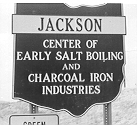 1. The sign
at the city limit shown in the opening of the Olde Forester's web site
on SCIOTO SALT SPRINGS ON SALT LICK CREEK
disappeared when U. S. 35 was made into a divided highway and is in a warehouse
somewhere, evidently. Let's find it and stand it on the Powell Memorial
Site beside the courthouse.
1. The sign
at the city limit shown in the opening of the Olde Forester's web site
on SCIOTO SALT SPRINGS ON SALT LICK CREEK
disappeared when U. S. 35 was made into a divided highway and is in a warehouse
somewhere, evidently. Let's find it and stand it on the Powell Memorial
Site beside the courthouse.
2. Computer accessibility of documents and maps explaining background
information and historic sites to be visited. P.A.R.K. files.
3. Printed information available at the John Wesley Powell Memorial
building on the Courthouse Square.
4. A GUIDED TOUR PROGRAM for the high tourist season, walking and/or
driving to prime sites with interpretive lectures. Properly promoted, people
would pay for this service.
5. Restoration of a SALT FURNACE CAMP in North Meadow Park with
all the tools and appurtenances, including pack horses. A goal of
expanding this into a museum of artifacts and bones of extinct animals
attracted to the licks.
6. MCKITTERICK EARTHWORKS: Acquisition, research and an
interpretive program to explain the function of the Indian rectangular
earthworks north of Boone Rock Shelter. This site might well have been
an astronomical observatory for agricultural guidance. It most certainly
was no fort. It is in a good position for observing the rising and setting
of the sun and moon.
7. A SALT LICK TRAIL SYSTEM FOR HIKERS. Remembering from
the original notes of the surveyors, "A blazed way leads to the Salt Springs
on Salt Lick Creek", relocate accurately the ancient trails to the
licks as recorded on the original survey plats. Provide access and
directions with interpretive literature or signing for walking these worn
down footpaths of the mammoths, mastodons, bison, Indians and explorers,
including the Lewis Wetzel rock shelter where he carved his name.
These ancient footpaths extend across all of Southeastern Ohio and cross
many state forests and game preserves; as well as, the Wayne National Forest.
Private lands are sparsely populated, often industrially owned where right-of-ways
could be obtained for long distance hiking.
Great events occurred along these ancient paths. For example,
General Lewis' army camped at the Salt Springs after the Battle of Point
Pleasant in October, 1774, while on their way to Lower Shawnee Town below
Circleville.
8. EDUCATIONAL RESEARCH AND CONFERENCES. No region of Ohio, to
my knowledge, is as gifted in resources for the study of the ecosystem
and anthropology. Support for this is stated in my opening paragraphs of
this proposal.
PLEA ON THE WWW FROM THE OLDE FORESTER
Anyone on the www agreeing with The Olde Forester about the SCIOTO SALT
SPRINGS ON SALT LICK CREEK as an important historical site which
needs to be made known and part of the OHIO BUCKEYE TOURISM PROGRAM, please
make your thoughts known to:
-
Ohio Historical Society
-
City officials of Jackson, Ohio, Executive offices, 145 Broadway
St., Jackson, OH 45640
-
Jackson County Chamber of Commerce, 382 Pearl St, Jackson, OH
45640 (740) 286-2722
-
Southeastern Ohio Regional Council
-
Smithsonian Institution, Bureau of Ethnology
-
State and Federal government officials
-
Ohio Department of Natural
Resources, Natural Areas and Preserves, and Parks
-
Nature Conservancy
-
Archaeological Conservancy
-
Sierra Club
-
Audubon Society
Return to Scioto Salt Springs and Scioto
Salt Works

Return
to The Olde Forester
Webmaster: Daughter Sandra
Conway Morrissey