Trail
Signal Trees
By Emmett A. Conway, Sr., The Olde
Forester
TRAIL SIGNAL TREES are extremely important historically. Native Americans
made them by bending a sapling and holding it by some means until the first
curve was fixed by growth. Apical dominance (a forester's term) or natural
trend to grow upright would straighten the upper part. They probably tied
it some way to hasten the fixation.
I have seen only one SIGNAL TREE. That was at LYNX PRAIREE in
Adams County, Ohio. We were at the dedication of the Lynx Prairee Nature
Preserve named in honor of a famous woman botanist from Cincinnati. Lucy
Braun ( I believe). She had published her extensive research findings on
Lynx Prairee. Along the trail leading from the road into the tract a large
white oak (I believe) was pointed out as A SIGNAL TREE.
SIGNAL TREE DISCOVERED ON WEDDINGTON HILL
I just received an E-mail (12/3/98) from Tom
O'Grady, a friend and amateur historian like myself. His specialty
is the canal systems of Ohio, but he just informed me that he thinks he
made an important discovery of a signal tree on Weddington Hill which is
south of Richmondale, Ohio.
The following is Tom's E-mail:
I made a trek over to the Scioto valley a few weeks back with
a few friends and we used your directions
from your web site to locate the smoke signal bowl.
 On the way up
the razor back ridge we took a short rest and found ourselves standing
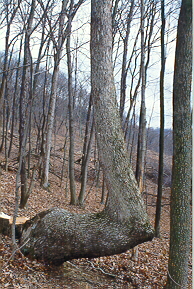
next to what appeared to resemble a signal tree. It looked like all
descriptions I've ever read about Indian signal trees. It was a white
oak with a diameter at waist height of about two feet. At that point
it took a 90 degree turn to the right as we were facing it and was parallel
to the ground for a few feet and then it took another 90 degree turn and
went straight up.
On the way up
the razor back ridge we took a short rest and found ourselves standing
next to what appeared to resemble a signal tree. It looked like all
descriptions I've ever read about Indian signal trees. It was a white
oak with a diameter at waist height of about two feet. At that point
it took a 90 degree turn to the right as we were facing it and was parallel
to the ground for a few feet and then it took another 90 degree turn and
went straight up.
Just after noticing the tree I looked up along the ridge in the direction
we were heading and it became very apparent that I was looking at an old
trail. It was very well defined because the wind had blown the fallen leaves
and filled the trailway. As one stepped into the trail it was obvious
that it was a very old, well beaten path snaking its way to the ridge top.
It led us right top the signal bowl as you described. From that point
we could see up the Scioto Valley toward Mount Logan, down the Scioto Valley
toward Omega, and off to the northeast along the old Teays Valley.
Needless to say we were all very impressed and inspired to do more exploring.
Unfortunately a large clear cutting operation was occurring while we were
there. They have cut trees right up to the trailside. Some of the
down trees fell or were bulldozed across the Warrior's Path. One
of the two lower signal bowls had a newly felled tree lying across it.
I believe the trail and the site have great historic value and would
make a fine park. Other than a few periodic hunters and yourself,
the area seems rarely visited; a stark contrast to the time when so many
travelers established such a well beaten thoroughfare.
I'm interested in finding out more about the Warrior's Path, more about
signal bowls in the Scioto Valley and the possibility of same in the Hockhocking
Valley.
Thanks a million for the guiding light.
The location is a most appropriate place for a Signal Tree. The
occurrence of Three Signal Bowls at different
elevations on Weddington Hill is one reason to mark the trail. Another
reason would be to confirm what may have been An Ancient Trail To the Salt
Springs. Someplace through here "The Pancake Trail" passed. (That is a
given name.)
From the top of Weddington Hill, at the upper Signal Bowl, a ridge runs
directly toward the Salt Licks for a long way passing Allen's Chapel. It
continues on an easy route I have followed to Jackson.
Return to Native American Indians

Return
to The Olde Forester
Webmaster: Daughter Sandra
Conway Morrissey